|
EXHIBITORS EQUIPMENT OUTDOOR DEMONSTRATIONS
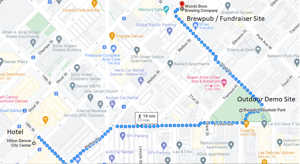
On Monday afternoon, March 21, participating exhibitors will demonstrate equipment at Benedict Fountain Park, within walking distance from the host hotel, Hilton Denver City Center Hotel.
Location: 401 E. 20th Avenue; Denver (bounded by 20th Avenue, Tremont Place and 22nd St.)
Time: 4:30 - 5:30 p.m.
Foerster Instruments Inc.
FOERSTER is known for FEREX 4.034 which is a fluxgate magnetometer based field computer designed for geophysical, military, and archeological use. Available with many options to enhance mapped data. Foerster now has a brand-new UAV based FEREX magnetometer. Information will be shared at this year’s 2022 SAGEEP event.
GSSI
GSSI, the world leader in GPR, will produce demonstrations of our new GS Series 200 HS antenna. This digital, wireless antenna features a 200 MHz center frequency and employs GSSI’s proprietary HyperStacking® technology. This technology improves signal to noise performance and increases depth penetration under all soil conditions.
Guideline Geo Americas
Come see Guideline Geo ABEM MALA demonstrate our newest utility locating designed ground penetrating radar (GPR), the MALA easy Locater (EL) Core. The MALA EL Core includes the best data quality and fastest workflow on the market, wireless data collection, and real-time interpretation through MALA AI.
Landviser, LLC
Landviser and Partners are Enlightening Research in Near Surface Geophysics and GIS Analytics. We develop and market ERT/IP/SP instruments (versatile compact LandMapper, expandable multi-channel SibER deep tomography sets), mobile EMI scanners (AEMP-14 and Geovizer), ride-on 3D GPR (TerraZond) – complete with software and training; conduct environmental, agricultural, and archaeological surveys worldwide.
Mount Sopris Instrument Company, Inc.
MSI will operate downhole televiewers, digital camera and borehole magnetic resonance at the Outdoor Demo event.
Seismic Source Company
We will be demonstrating both the Seismic Source DX-6 seismograph and Geogiga's SurfaceRT software. This includes equipment deployment, SPAC data collection and generating dispersion curves in real time.
Sensors & Software, Inc.
Please join Greg and Dave from Sensors & Software at the outdoor demonstration where we will be showing Noggin GPR technology. GPR images the subsurface and is used in many applications including utility-locating, scanning structures such as bridges, roads and buildings, detecting USTs and voids, geological stratigraphy, archaeology and forensics.
Outdoor Demo Site (Benedict Fountain Park) and Brewpub "Field Trip" Fundraiser immediately following
|

